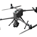
The DJI Mavic 3M Multispectral Drone pairs a 20MP RGB camera with four 5MP multispectral cameras (green, red, red edge, and near infrared) to give agriculture and surveying teams both visible-light imagery and crop health data in a single flight. An integrated RTK module and omnidirectional obstacle avoidance support centimeter-level accuracy, including terrain following on sloped landscapes.
Features
- 20MP RGB + four 5MP multispectral sensors capture green, red, red edge, and near-infrared bands alongside visible-light imagery.
- Integrated RTK module enables centimeter-level positioning accuracy.
- Omnidirectional obstacle avoidance wide-FOV sensors for safe flight over sloped terrain.
- Integrated sunlight sensor improves multispectral data consistency across flights.
- Up to 43 minutes of flight time per charge for greater coverage on every mission.
- O3 Enterprise transmission reaches up to 9.3 miles (15 km).
- Built for precision agriculture well suited to orchard mapping, crop health analysis, and field surveys.
Specifications
Aircraft
| Net Weight (with propellers and RTK module) | 951 g |
| Max Takeoff Weight | 1,050 g |
| Dimensions (Folded, without propellers) | 223 × 96.3 × 122.2 mm (L × W × H) |
| Dimensions (Unfolded, without propellers) | 347.5 × 283 × 139.6 mm (L × W × H) |
| Diagonal Length | 380.1 mm |
| Max Ascent Speed | 6 m/s (Normal Mode) 8 m/s (Sport Mode) |
| Max Descent Speed | 6 m/s (Normal Mode) 6 m/s (Sport Mode) |
| Max Flight Speed (at sea level, no wind) | 15 m/s (Normal Mode) Sport Mode: forward 21 m/s, sideways 20 m/s, backward 19 m/s |
| Max Wind Speed Resistance | 12 m/s |
| Max Takeoff Altitude Above Sea Level | 6,000 m (without a payload) |
| Max Flight Time (without wind) | 43 minutes |
| Max Hover Time (without wind) | 37 minutes |
| Max Flight Distance | 32 km |
| Max Pitch Angle | 30° (Normal Mode) 35° (Sport Mode) |
| Max Angular Velocity | 200°/s |
| GNSS | GPS + Galileo + BeiDou + GLONASS (GLONASS supported only when RTK module is enabled) |
| Hovering Accuracy (Vertical) | ±0.1 m (Vision Positioning) ±0.5 m (GNSS Positioning) ±0.1 m (D-RTK) |
| Hovering Accuracy (Horizontal) | ±0.3 m (Vision Positioning) ±0.5 m (HD Positioning) ±0.1 m (RTK) |
| Operating Temperature | -10° to 40° C (14° to 104° F) |
| Internal Storage | N/A |
| Motor Model | 2008 |
| Propeller Model | 9453F Enterprise Edition |
| Light Sensor | Built-in module |
RGB Camera
| Image Sensor | 4/3 CMOS, 20 MP effective pixels |
| Lens | FOV: 84° Equivalent focal length: 24 mm Aperture: f/2.8 to f/11 Focus: 1 m to ∞ |
| ISO Range | 100-6400 |
| Shutter Speed | Electronic: 8-1/8000 s Mechanical: 8-1/2000 s |
| Max Image Size | 5280 × 3956 |
| Photo Shooting Modes | Single shot: 20 MP Timed: 20 MP JPEG: 0.7/1/2/3/5/7/10/15/20/30/60 s JPEG + RAW: 3/5/7/10/15/20/30/60 s Panorama: 20 MP (original material) |
| Video Resolution (H.264) | 4K: 3840 × 2160 @ 30fps FHD: 1920 × 1080 @ 30fps |
| Max Video Bitrate | 4K: 130 Mbps FHD: 70 Mbps |
| Supported File System | exFAT |
| Image Format | JPEG / DNG (RAW) |
| Video Format | MP4 (MPEG-4 AVC/H.264) |
Multispectral Camera
| Image Sensor | 1/2.8-inch CMOS, 5 MP effective pixels |
| Lens | FOV: 73.91° (61.2° × 48.10°) Equivalent focal length: 25 mm Aperture: f/2.0 Focus: Fixed focus |
| Spectral Bands | Green (G): 560 ± 16 nm Red (R): 650 ± 16 nm Red Edge (RE): 730 ± 16 nm Near Infrared (NIR): 860 ± 26 nm |
| Gain Range | 1x-32x |
| Shutter Speed | Electronic: 1/30-1/12800 s |
| Max Image Size | 2592 × 1944 |
| Image Format | TIFF |
| Video Format | MP4 (MPEG-4 AVC/H.264) |
| Photo Shooting Modes | Single shot: 5 MP Timelapse: 5 MP TIFF: 2/3/5/7/10/15/20/30/60 s |
| Video Resolution (H.264) | FHD: 1920 × 1080 @ 30fps Video content: NDVI / GNDVI / NDRE |
| Max Video Bitrate | Stream: 60 Mbps |
Gimbal
| Stabilization System | 3-axis mechanical gimbal (tilt, roll, pan) |
| Mechanical Range | Tilt: -135° to 45° Roll: -45° to 45° Pan: -27° to 27° |
| Controllable Range | Tilt: -90° to 35° Pan: Not controllable |
| Max Control Speed (Tilt) | 100°/s |
| Angular Vibration Range | ±0.007° |
Sensing System
| Sensing System Type | Omnidirectional binocular vision system with an infrared sensor on the bottom of the aircraft |
| Forward | Measuring range: 0.5-20 m Detection range: 0.5-200 m Effective avoidance speed: ≤15 m/s FOV: 90° horizontal, 103° vertical |
| Backward | Measuring range: 0.5-16 m Effective avoidance speed: ≤12 m/s FOV: 90° horizontal, 103° vertical |
| Lateral | Measuring range: 0.5-25 m Effective avoidance speed: ≤15 m/s FOV: 90° horizontal, 85° vertical |
| Upward | Measuring range: 0.2-10 m Effective avoidance speed: ≤6 m/s FOV: 100° front/rear, 90° left/right |
| Downward | Measuring range: 0.3-18 m Effective avoidance speed: ≤6 m/s FOV: 130° front/rear, 160° left/right |
| Operating Environment | Front, rear, sides, above: surfaces with clear patterns and adequate lighting (>15 lux) Below: diffuse reflective surfaces with >20% reflectivity (walls, trees, people, etc.) and adequate lighting (>15 lux) |
Video Transmission
| Transmission System | DJI O3 Image Transmission Industry Edition |
| Live View Quality | Remote controller: 1080p / 30fps |
| Operating Frequency | 2.400-2.4835 GHz 5.725-5.850 GHz |
| Max Signal Distance (unobstructed, no interference) | FCC: 15 km CE / SRRC / MIC: 8 km |
| Max Transmission Distance (obstructed) | Strong interference (urban, residential): 1.5-3 km (FCC/CE/SRRC/MIC) Medium interference (suburban, city parks): 3-9 km (FCC), 3-6 km (CE/SRRC/MIC) Weak interference (remote fields, open farmland): 9-15 km (FCC), 6-8 km (CE/SRRC/MIC) |
| Max Download Speed | 15 MB/s (with DJI RC Pro Industry Edition) |
| Latency | Approx. 200 ms (depending on environment and mobile device) |
| Antennas | 4 antennas, 2 transmitting and 4 receiving |
| Transmitter Power (EIRP) | 2.4 GHz: <33 dBm (FCC), <20 dBm (CE/SRRC/MIC) 5.8 GHz: <33 dBm (FCC), <30 dBm (SRRC), <14 dBm (CE) |
| Other | Supports the DJI Cellular module |
Product Identifiers
| Manufacturer SKU/MPN | CP.EN.00000444.01 |
| UPC | 190021075764 |
Applications
From emergency response to energy infrastructure, the Matrice 4TD adapts to the industries that rely on aerial thermal and visual data most.
-
Public Safety
Gives first responders a faster, safer way to assess a scene, cutting response times and operational costs while keeping personnel out of harm's way.
-
Powerline Inspection
Supports utility teams monitoring construction, running inspections, and handling maintenance across electrical grids and plants.
-
Geographic Information
Streamlines topographic surveys and a range of mapping data outputs, lowering operational cost per project.
-
Oil and Natural Gas
Improves efficiency in management, inspection, and construction across oil and gas operations while reducing costs.
-
Renewable Energy
Automates inspection along set flight paths, helping protect personnel and boost power generation output.
-
Roads and Bridges
High-resolution and thermal imaging allow close inspection of critical components such as decks, piers, and cables.
-
Water Conservancy & Maritime
Aids monitoring and inspection work across waterways, dams, and maritime infrastructure.
What's Included
- 1 × DJI Mavic 3M Aircraft with RTK Module & SD Card
- 1 × Battery
- 1 × Remote Controller
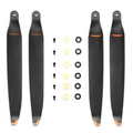
- 3 × Propeller Pair
- 1 × Charger
- 1 × Carrying Case
- 1 × USB-C to USB-C Cable
- 1 × Power Cable
- 1 × USB-C Cable
- 1 × Screwdriver
- Manuals
Vision Velocity Tech backs every Mavic 3M with our standard return and refund coverage. Full policy details, timelines, and eligibility are outlined on our Return and Refund Policy page.
Need help with multispectral survey setup, RTK configuration, or a warranty claim? Reach our support team directly.
✉ info@visionvelocitytech.com
🕒 Mon-Fri, 9am-5pm MST
📞 385-612-9388